Assistant Professor Edward Park from the Humanities & Social Studies Education (HSSE) Academic Group proves that the COVID-19 pandemic is no barrier to the study of Physical Geography.
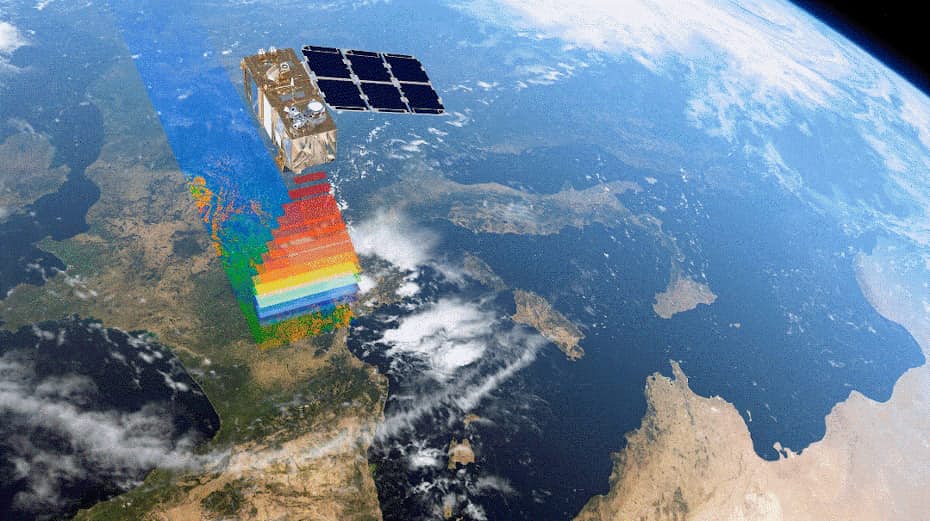
Remote sensing is an interdisciplinary field of science that uses satellite-mounted sensors to acquire spatio-temporal information about the Earth’s surface. One of the key advantages of remote sensing is that it enables the collection and measurement of environmental data without having to be in the field. For this reason, remote sensing is the fastest growing technology within the disciplines of Earth and Environmental Science, and Physical Geography.
The opportunity to use remote sensing technology in their Final Year Projects (FYP) provided eight Geography students under Assistant Professor Park with a sense of renewed excitement. They were supposed to have gone on a two-week field trip to Siem Reap, Cambodia, in December 2020—an FYP highlight that had to be cancelled due to travel restrictions arising from the COVID-19 pandemic. Assistant Professor Park, the leader of the mission, was initially deeply concerned that his students could not collect any field data for their FYP. “Without the trip, their FYP would be no different from any other term project completed largely based on literature review,” he thought.
Undeterred by the circumstances, Assistant Professor Park decided to change his students’ approach to data collection. Introducing remote sensing into their research methodology, he showed the students how to download satellite images of the relevant sites on Earth. He also guided them on processing and analysing the images to obtain meaningful information about their study sites. With the adoption of remote sensing, the students were free to take their exploration anywhere around the world, from Cambodia to Myanmar and even the Amazon. It would also empower their study of significant issues, such as the collapse of mining dams, or the impact of hydroelectric dams and sand mining on the environment.
“Investigation into such academically significant research topics were previously not possible due to the limited spatial scale of conventional FYP fieldwork. Although our Geography majors could not travel overseas, they saw this as a good opportunity to acquire new skills in remote sensing, which I think is crucial for Geography students. I am proud of what my students achieved through their first hands-on experience,” said Assistant Professor Park.
Gaining broader perspectives and fresh insights
Among the FYP students was Ms Quek Yu Pin, who used remote sensing techniques to investigate the environmental causes underlying the collapse of a jade mining dam in Northern Myanmar—a disaster that killed about 200 people on 2 July 2020. She used high-resolution satellite imagery to map the boundary of the landslide, analysed soil moisture trends to understand the moisture dynamics before the collapse, and measured the subsidence rate of the dam up to six months prior to its collapse using the Interferometric Synthetic Aperture Radar (InSAR). These insights enabled her to conclude that the dam had failed due to the water seepage from piping erosion after the dam became saturated with water—an indication of its poor construction.
Yu Pin shared, “Through my FYP, I was able to gain valuable hands-on experience in researching an important human-environment issue in the region. More importantly, I believe I have established the cause of the mining dam failures in Myanmar, a long-standing problem driven by the country’s booming jade mining industry.”
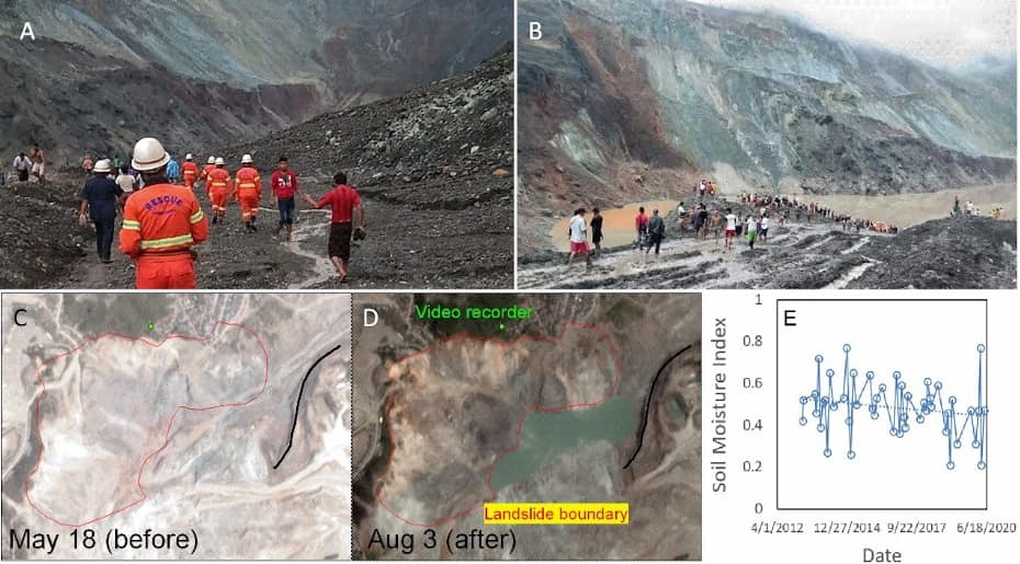
A and B: Picture of the collapsed dam site (from news articles). C and D: High-resolution images of the landslide boundary, before and after the collapse of the dam. E: Changes in the soil moisture index over the collapsed dam since 2013, mapped from Landsat data.
Ms Karina Sheri also benefited from the use of remote sensing, which brought her broader perspectives and deeper knowledge on global environmental issues. Karina had hypothesised that the two largest dams in South America (Santo Antonio and Jirau Dams) inflicted a critical loss of morphodynamics in the Madeira River (the most important tributary of the Amazon River) in Brazil, and was able to validate her findings by analysing the multi-temporal remote sensing dataset.
Ms Ng Wen Xin’s FYP investigated the causes underlying the shrinking of Tonle Sap, Southeast Asia’s largest freshwater lake in Cambodia. She hypothesised that this was related to the intensive riverbed mining around Phnom Penh and in the lower Mekong, and was able to verify her findings through the analysis of multi-temporal high-resolution satellite images.
Assistant Professor Park is greatly heartened by these outcomes. “Our students have not only developed in-depth research projects on important environmental issues, they have also acquired useful geospatial and analytical skills. That is a huge bonus in the context of our increasingly globalised and digitalised society,” he said.
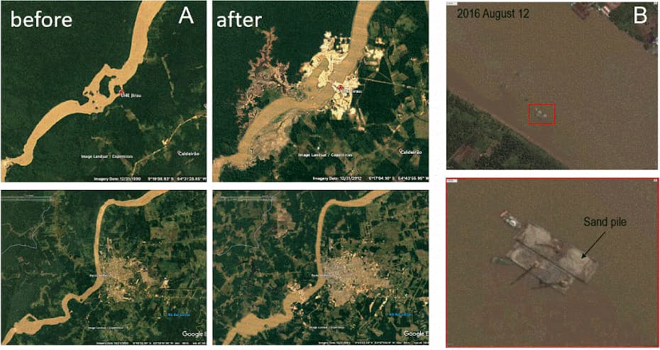
A: Impact on the Amazon River in Brazil, before and after the construction of the Santo Antonio Dam. B: An example of a typical riverbed mining barges in the lower Mekong.